- Stock: In Stock
- Model: RDDLZ-LM-3703
- Weight: 1.00
- SKU: RDDLZ-LM-3703
Available Options
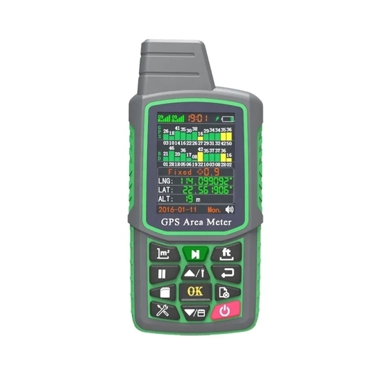
Low cost surveyor measuring equipment for sale, supporting GPS, BeiDou, GLNS, distance measurement, graphic tracking, and data logging functions. The handheld digital land surveyor is easy to use, with its clear digital display and intuitive controls, making it easy to use even for beginners.
Specification
- Model: RDDLZ-LM-ZK3701-3
- Built-in Chip: GPS+GLNS+Beidou
- GPS Receiver: Chip processor
- Antenna: Built-in GPS+BeiDou dual mode
- Area Error: 0.5%
- Distance Accuracy: 0.5 M
- Time Accuracy: ±0.1 Second
- Positioning Accuracy: 1.0CEP
- Display: 2.4-inch TET-LCD color screen
- Keypad: Silicone keypad
- Data Interface: Micro-USB2.0 interface
- Power Supply: 3.7V lithium battery, 2 batteries
- Records: 120
- Audio: Speaker
- Operating Temperature: -20°C~+60°C
- Dimension: 128mm* 60mm 24mm
Features
- Multi-functional GPS land meter with multi-clock measurement modes, automatic trajectory, aspect mode, distance measurement, spot measurement, in-vehicle measurement, slope measurement in fixed width mode.
- Once the measurement is complete, the value is displayed, the graphical trajectory is displayed and the price is calculated automatically.
- The land meter can save and record up to 99 historical data and graphical traces. You can look up, check and delete the history at any time.
- The land surveying equipment allows you to set the unit price of the area, the unit price of the length, the conversion factors for acres and square meters and to set the automatic and manual measurement methods.
- The GPS land meter can be connected to a PC to export and print data.
- Dual lithium batteries for long life, 3-5 days standby time, 8-10 hours continuous measurement.
Dimension (Unit: mm)
Details
Applications
A land meter, also known as land surveying equipment, they are used to measure distances, angles, and elevations, and is commonly used in construction, engineering, and mining industries to establish property boundaries, create topographical maps, and determine the position of underground utilities. Land meters are also used in scientific research and environmental monitoring to measure changes in the landscape and to study soil erosion, sedimentation, and other geologic processes. Additionally, they are used in agriculture to measure crop yields and monitor the health of crops.
Tips: What is the accuracy of this land surveying equipment?
The accuracy of land surveying equipment can vary depending on the type of equipment used and the conditions in which it is used.
Some common types of land surveying equipment include total stations, global positioning system (GPS) receivers, and digital levels. The accuracy of these devices can be affected by factors such as environmental conditions, the skill of the surveyor, and the quality of the equipment itself.
Total stations, which use a combination of angle and distance measurements to determine the location of points on the ground, typically have an accuracy of a few millimeters to a few centimeters. GPS receivers, which use signals from satellites to determine location, can have an accuracy of a few centimeters to a few meters, depending on the type of GPS receiver used.
It's important to note that achieving high accuracy in land surveying requires careful planning, proper calibration of the equipment, and a thorough understanding of the surveying process. Therefore, the accuracy of any given land surveying equipment can vary depending on how it is used and the expertise of the surveyor.
